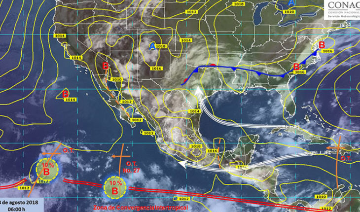
Mexico.-for today, the tropical wave No. 27 will no longer affect the country. Moreover, the presence of upper unstable air over the North, West and South of the country, in interaction with abundant entry of warm and humid air from the Pacific Ocean and Gulf of Mexico, will generate the development of clouds with electrical activity in the following entities: forecast maximum precipitation (accumulated in 24 h) for today, 13 August 2018: isolated strong storms very strong (50 to 75 mm): Chihuahua, Coahuila, Durango, Zacatecas, Aguascalientes, Guanajuato, Veracruz, Jalisco, Michoacán, Guerrero, Oaxaca and Chiapas.
Intervals of showers with isolated strong storms (25 to 50 mm): Sonora, Sinaloa, Colima, San Luis Potosí, Querétaro, Puebla, State of Mexico, Tabasco, Campeche, Yucatán and Quintana Roo.
Rain with squalls (5.1 to 25 mm) in areas of intervals: Baja California, Nuevo Leon, Tamaulipas, Nayarit, Hidalgo, Tlaxcala, Morelos and city of Mexico.
Rains isolated (0.1 to 5 mm) in zones: Baja California.
Note: Storm areas may be accompanied by lightning, falling hail, strong gusts of wind, as well as possible development of whirlwinds or storms in the North of the country.
Forecast temperatures for today August 13, 2018: temperatures exceeding 45° c low: California and Sonora.
Maximum temperatures of 40 to 45 ° c areas of Baja California Sur, Sinaloa, Michoacan, Coahuila, Nuevo Leon and Tamaulipas.
Maximum temperatures of 35 to 40 ° C: areas of Nayarit, Jalisco, Colima, Guerrero, Oaxaca, Chiapas, Chihuahua, Durango, Zacatecas, San Luis Potosí, Morelos, Veracruz, Tabasco, Campeche, Yucatán and Quintana Roo.
Forecast winds for today August 13, 2018: gusts of wind that can exceed 50 km/h: Baja California, Baja California Sur, Coahuila, Nuevo León, San Luis Potosí and Tamaulipas, as well as the coast of Campeche and Yucatan.
Forecast by region: Valle de Mexico: morning is expected to sky means cloudy with presence of banks of mist or fog in mountainous areas, the afternoon will be presented isolated strong storms in the State of Mexico and downpours in the city ranges from Mexico, both accompanied by electrical activity ranges. The wind will be westerly at 15 to 30 mph. The city of Mexico provides for a maximum temperature of 23 to 25° C and a minimum of 12 ° c to 14° C; for the State of Mexico, maximum temperature of 22-24° C and a minimum of 8 to 10° C.
Baja California Peninsula: Sky cloudy by the afternoon, with intervals of squalls in Baja California Sur and rains in Baja California. Hot environment and northwest wind with gusts that may exceed the 50 mph North Pacific: Sky cloudy with strong storms accompanied by electrical activity in the region. Hot environment and wind from the West and Northwest at 15 to 30 km/h. Pacific Center: Sky cloudy with very strong specific storms accompanied by electrical activity in strong squalls in Nayarit and Colima Jalisco and Michoacán, is expected in the afternoon. Warm atmosphere and wind direction variable of 15 to 30 km/h in the region, with gusts that may exceed the 50 km/h in areas of thunderstorms.
South Pacific: Cloudy sky, with very strong isolated thunderstorms accompanied by electrical activity in the region. Warm atmosphere and winds of variable direction of 15 to 30 km/h in the region, with gusts that may exceed the 45 km/h in areas of thunderstorms.
Gulf of Mexico: Sky cloudy afternoon with accompanied by electrical activity in Tabasco strong very strong in Veracruz and punctual timely storms, as well as rainfall with intervals of showers in Tamaulipas. Banks of fog morning in mountainous areas. Warm atmosphere and wind from the East and Southeast of 20 to 35 km/h in the region, with gusts exceeding 50 km/h in Tamaulipas.
Yucatan Peninsula: Sky cloudy in the afternoon with isolated storms strong in the region. Hot environment and wind of the East and northeast of 20 to 35 km/h in the region, with gusts to 50 mph on the coast of Campeche and Yucatan.
Table of the North: Sky cloudy with very strong specific storms accompanied by electrical activity in Chihuahua, Coahuila, Durango, Zacatecas and Aguascalientes; strong in San Luis Potosí, as well as intervals of showers in Nuevo Leon. Warm atmosphere and wind direction variable from 20 to 35 km/h in the region, with gusts that may exceed the 50 km/h in Coahuila, Nuevo León and San Luis Potosí.
Central table: Cloudy afternoon sky, waiting is very strong in Guanajuato occasional storms, strong in intervals of showers in Hidalgo, Tlaxcala and Morelos and Puebla, the rains will be accompanied by electrical activity. The environment will be warm to hot, with wind from the North and northeast from 20 to 35 km/h in the region, with gusts to 45 mph in areas of thunderstorms.
The maximum rainfall of the last 24 hours (in mm) were recorded in: Carranza, Coah., 83.6; San Luis Potosí, S.L.P., 52.1; Aguascalientes, Ags., 49.8; Toluca, Edo. of MEX., 40.3; Loreto, Zac., 38.6; Arriaga, Chis., 37.9; Tlalpan forest, CD. de MEX., 32.8 and Hidalgo del Parral, Chih., 32.3.
Maximum temperatures (in ° C) were recorded at: cottons, B.C., 43.5; La Paz, B.C.S., 38.6; Ciudad Victoria, Tamps. and Campeche, chap. 37.4; Villahermosa, Tab. and Salina Cruz, Oax., 37.0; Altar, Sonora, Merida, Yuc. and Acapulco, Gro., 36.5 and Tacubaya, CD. de MEX., 22.0.
Minimum temperatures (in ° C) were recorded in: San Cristóbal de las Casas, Chis., 8.8; Toluca, Edo. of MEX., 10.0; Pachuca, Hgo., 11.3; Zacatecas, Zac., 11.4; Tlaxcala, Tlax., 12.7 and Tacubaya, CD. de MEX., 13.5.


