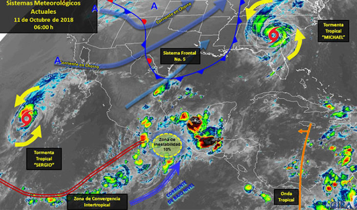
Valley of Mexico: Sky cloudy in the afternoon with isolated strong storms accompanied by electrical activity, strong winds and possible freezers in the city of Mexico and State of Mexico. The wind will be East of 10 to 25 mph with gusts to 40 mph in areas of thunderstorms. The city of Mexico provides for a maximum temperature of 23 to 25° C and a minimum of 13 to 15° C. For the State of Mexico, maximum temperature of 22-24° C and a minimum of 9 to 11° C.
Baja California Peninsula: intense sky cloudy with isolated storms in Baja California Sur and point very strong storms in Baja California, both accompanied by electrical activity, strong winds and possible hail. Warm temperate environment and wind from the West and southwest of 25 to 40 km/h, to intensify this evening, reaching gusts of up to 70 km/h and waves of 2 to 3 meters on the West coast of the region.
North Pacific: Sky cloudy with storms strong squalls in Sinaloa and Sonora. Warm and wind from the South and Southwest 25 to 35 mph, with gusts that may exceed 40 km/h in areas of thunderstorms.
Pacific Center: Half sky cloudy during the day, in the afternoon will increase cloud cover, expecting isolated strong storms with thunderstorms in Michoacan, as well as intervals of showers elsewhere in the region. Warm atmosphere and wind of variable direction at 15 to 30 mph, with gusts to 40 mph in areas of thunderstorms.
South Pacific: Cloudy skies with occasional storms intense accompanied by hailstorms in the region possible and electrical activity. Warm and wind direction variable 20 to 35 km/h, with gusts that may exceed the 50 km/h on shores of the sector.
Gulf of Mexico: Sky cloudy with occasional intense storms in Veracruz and very strong in Tamaulipas and Tabasco, the rains will accompany electrical activity and hailstorms. Warm and wind of the East and northeast of 25 to 35 mph, with gusts that may exceed the 50 km/h in Tamaulipas.
Yucatan Peninsula: Sky cloudy in the afternoon with isolated storms very strong in Campeche, as well as isolated forts in Yucatan and Quintana Roo. Hot environment and wind from the North and Northeast at 15 to 30 mph, with gusts to 40 mph in areas of storm.
Table of the North: Sky cloudy in the afternoon with isolated strong storms accompanied by activity electrical and possible hail in Coahuila, Nuevo León and San Luis Potosí, as well as intervals of showers in Chihuahua, Durango, Zacatecas and Aguascalientes. Warm and wind direction variable of 15 to 30 km/h, with gusts that may exceed the 50 km/h in Chihuahua and Durango.
Central table: Sky cloudy with specific intense in Puebla, isolated strong storms in Queretaro, Hidalgo, Morelos and Tlaxcala, both accompanied by electrical activity and possible hail, as well as intervals of showers in Guanajuato. Warm and wind direction variable of 15 to 30 km/h, with gusts that may exceed the 40 km/h in areas of storm.
translated from Spanish: They predict intense isolated storms in Baja California Sur, Veracruz, Puebla, Guerrero, Oaxaca and Chiapas
October 11, 2018 |


