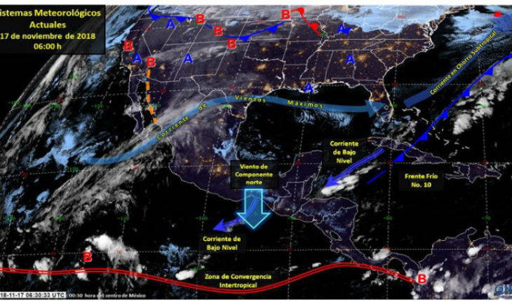
-photography/Conagua CDMX.-the establishment of an area of high pressure in the Gulf of Mexico will create stable conditions with low potential for rain and daytime temperatures gradually rising on much of the national territory. However, even is expected cold temperatures during the morning and evening in the States of the North and centre of the territory, as well as wind of Northern component with gusts exceeding 70 mph in the isthmus and Gulf of Tehuantepec. Above weather systems will favour the following potentials of rain:
(accumulated in 24 h) maximum precipitation forecast for today, 17 November 2018: rain with squalls (5.1 to 25 mm) in areas of intervals: Tamaulipas and Veracruz.
Isolated rain (0.1 to 5.0): Coahuila, Nuevo León, Puebla, Tabasco, Oaxaca, Chiapas, Yucatan and Quintana Roo.
Prognosis of minimum temperatures for today 17 November 2018: minimum temperatures below – 5 ° C: Sierras of Baja California, Chihuahua and Durango.
Minimum temperatures of 0 to – 5 ° C: saws, Sonora, Coahuila, new Leon, Zacatecas, San Luis Potosí, Aguascalientes, Jalisco, Guanajuato, Hidalgo, Tlaxcala, Puebla, State of Mexico, and Veracruz.
Minimum temperatures of 0 to 5 ° C: Sierras of Baja California, Tamaulipas, Queretaro, Morelos, city of Mexico and Oaxaca.
Maximum temperatures of 35 to 40 ° C: zones of Sinaloa, Nayarit, Jalisco, Colima, Michoacan, Guerrero, Oaxaca and Chiapas.
forecast winds for today 17 November 2018: wind of Northern component with gusts exceeding 70 km/h: isthmus and Gulf of Tehuantepec.
forecast by region:
Valley of Mexico: mostly cloudless sky throughout the day, with possible morning fog banks. Wind West 10 to 25 mph component The city of Mexico provides for a maximum temperature of 22-24° C and a minimum of 8 to 10° C. For the State of Mexico, maximum temperature of 21 ° c to 23° C and a minimum of 0 to 2° C.
Baja California Peninsula: Sky partially cloudy, ambient warm during the day and wind direction variable of 15 to 30 km/h. North Pacific: partially cloudy skies. Hot environment during the day and wind direction variable of 15 to 30 km/h. Pacific Center: partially cloudy skies most of the day. Hot environment and West wind of 15 to 30 km/h. South Pacific: partially cloudy skies during the day, in the afternoon is expected rains in Oaxaca and Chiapas. Banks of fog in mountainous areas. Warm atmosphere. Wind variable 15 to 30 km/h and address northern component with gusts that may exceed 70 km/h in the isthmus and Gulf of Tehuantepec (Oaxaca and Chiapas).
Gulf of Mexico: half sky cloudy intervals of showers in Tamaulipas and Veracruz, as well as rains in Tabasco. Warm atmosphere. Banks of fog in mountainous areas of Veracruz. Wind from the East and Southeast of 20 to 35 km/h. Yucatan Peninsula: partially cloudy skies during the day, in the afternoon is expected rainfall in Yucatán and Quintana Roo. Warm and wind from the Northeast at 15 to 30 km/h. table of the North: mostly clear sky. Afternoon is expected rains isolated in Coahuila and Nuevo Leon. Tempered atmosphere during the day with winds of variable address from 20 to 35 km/h for most of the region.
Central table: Partially cloudy skies throughout the day, the afternoon is expected rains isolated in Puebla. Tempered atmosphere throughout the day, as well as possible morning frosts in the Highlands. Tempered atmosphere during the day and wind variable 10 to 25 km/h. sources address: Conagua
translated from Spanish: It will gradually increase the temperature the weekend
November 17, 2018 |


