Photo/MTF
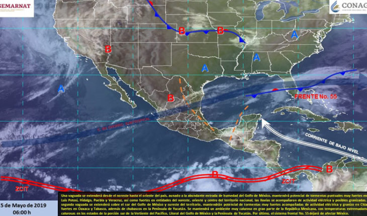
Mexico.-For today, a Vaguada will extend from the northeast to the east of the country, coupled with the abundant moisture inlet of the Gulf of Mexico, maintain potential of very strong punctual storms in San Luis Potosí, Hidalgo, Puebla and Veracruz, as well as strong Entities of the northeast, East and center of the national territory, the rains will be accompanied by electric activity and possible hailstorms. A second Vaguada will be extended over the south of the Gulf of Mexico and southeast of the territory, will maintain potential of very strong storms accompanied by electric activity and hail in Chiapas, strong in Oaxaca and Tabasco, as well as showers in the Yucatan Peninsula. It will maintain a very hot atmosphere in much of the Mexican Republic, with extremely hot temperatures in the states of the south portion of the Pacific Slope, littoral of the Gulf of Mexico and the Yucatan Peninsula. Finally, the frontal system No. 55 will cease to affect Mexico.
Note: Today May 15 begins the season of tropical cyclones in the northeastern Pacific Ocean.
Precipitation forecast for today May 15, 2019:
Strong thunderstorms with very strong punctual storms (50 to 75 liters per square metre): San Luis Potosí, Hidalgo, Puebla, Veracruz and Chiapas.
Showers intervals with strong punctual storms (25 to 50 liters per square metre): Nuevo León, Tamaulipas, Queretaro, Oaxaca and Tabasco.
Showers intervals (5.1 to 25 liters per square metre): Coahuila, Guanajuato, Tlaxcala, Yucatan and Quintana Roo.
Isolated rains (0.1 to 5.0 liters per square metre): Zacatecas, Estado de Mexico and Campeche.
Maximum temperature forecast for today May 15, 2019:
Temperatures above 45 °c: areas of Michoacán, Guerrero, Campeche and Yucatán.
Temperatures from 40 to 45 ° C: Areas of Veracruz, Tabasco, Oaxaca, Chiapas, Queretaro, Morelos, Nayarit, Jalisco and Colima.
Temperatures from 35 to 40 °c: areas of Sonora, Sinaloa, Coahuila, Durango, Zacatecas, San Luis Potosí, Tamaulipas, Guanajuato, Hidalgo, Puebla and Quintana Roo.
Wind forecast for today May 15, 2019:
Wind with gusts higher than 50 km/h: Baja California, Baja California Sur, Sonora, Zacatecas, Coahuila, San Luis Potosí, Aguascalientes, Jalisco, Nayarit, Hidalgo, Puebla and Costas de Campeche, Quintana Roo and Yucatán.
Forecast by Region:
Valle de México: Sky partially cloudy, with mist and rains isolated for the state of México, which will be accompanied by electrical activity. Hot atmosphere and Southwest wind from 10 to 25 km/h in the region, with gusts up to 40 km/h in storm areas. In Mexico City, a maximum temperature of 29 to 31 °c and a minimum of 14 to 16 °c is envisaged. For the state of México, maximum temperature of 28 to 30 °c and minimum of 4 to 6 º C.
Baja California Peninsula: Sky Clear most of the day. Morning fog banks on the west coast. Warm atmosphere during the day. West Wind from 20 to 35 km/h with gusts higher than 50 km/h in the region.
North Pacific: Clear sky and warm atmosphere. Wind from the west and southwest from 10 to 25 km/h with gusts that can exceed 50 km/h in Sonora.
Pacific Center: Clear sky and warm atmosphere. Northwest Wind from 10 to 25 km/h with gusts that can exceed 50 km/h in Jalisco and Nayarit.
South Pacific: Sky partially cloudy during the day, in the afternoon will increase the cloudiness, waiting for very strong punctual storms in Chiapas and forts in Oaxaca, accompanied by electric activity and possible fall of hail. Very hot atmosphere to extremely hot and South wind from 10 to 25 km/h, with gusts of 40 km/h in areas of storms.
Gulf of Mexico: Sky partially cloudy during the day, in the afternoon will increase the cloudiness, waiting for very strong punctual storms in Veracruz, as well as forts in Tamaulipas and Tabasco, the rains will be accompanied by electrical activity and possible Hailstorms. Warm atmosphere to very hot and wind from the east and southeast from 20 to 35 km/h, with gusts up to 45 km/h in storm areas.
Yucatan Peninsula: Clear Sky most of the day with an increase of cloudy afternoons, showers are planned in Yucatan and Quintana Roo, as well as isolated rains in Campeche. Extremely hot atmosphere and wind from the east and southeast from 10 to 25 km/h, with gusts higher than 50 km/h in the coasts of the region.
Table of the North: Sky partially cloudy in the morning, with increase of the overcast in the afternoon and potential of very strong punctual storms in San Luis Potosí, strong in Nuevo León and showers in Coahuila, which will be accompanied by electrical activity and possible Hail fall, as well as isolated rains in Zacatecas. Hot atmosphere and West wind from 10 to 25 km/h, with gusts above 50 km/h in much of the region.
Central table: Sky clear during the day with increase of the overcast in the afternoon, we foresee storms very strong punctual in Hidalgo and Puebla, strong in Queretaro and intervals of showers in Guanajuato and Tlaxcala, which will be accompanied of activity Electric and possible slush. Hot atmosphere and variable direction wind from 10 to 25 km/h, with gusts above 50 km/h in Hidalgo and Puebla.
The maximum rainfall of the last 24 hours (in millimeters) was recorded in:
Miguel Alemán, Tamps. 114 mm and San Nicolas de los Garza, N.L., 41.4 mm
Maximum temperatures (in °c) were recorded in:
Campeche, Camp., 40.8; Mérida, Yuc., 40.6; Tuxtla Gutierrez, Chis., 40.3; Hermosillo, Son., 40.0; Choix, Sin., 39.0; Coatzacoalcos, Ver., 39.0; Verde River, SLP., 38.8; Soto La Marina, Tamps., 38.7; Villahermosa, Tab., 37.9 and Tacubaya, Cd. de Méx., 31.7
Minimum temperatures (in °c) were recorded in:
Toluca, Méx., 7.5; Temosachi, Chih., 9.2; Durango, Dgo., 14.0, Guadalajara, Jal., 14.7 and Aeropuerto, CDMX. 18.0.
Source: National Meteorological Service
Mtf
translated from Spanish: Very strong rains in the northeast, east and southeast of Mexico, very hot atmosphere in much of the Mexican Republic
May 15, 2019 |


