Photo/MTF
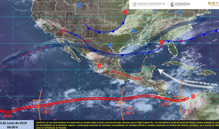
Mexico.-For today, the front No. 61 with stationary features will dissipate over the coasts of Tamaulipas, while in the afternoon is expected to arrive a new frontal system to the border states of northern Mexico, while Tropical wave No. 2 is Extend to the south of the coast of Oaxaca, both systems will be combined with instability in the upper atmosphere, causing potential storms accompanied by electric activity and possible slush in northeastern states, West, south and southeast Mexico, As well as in the Yucatan Peninsula. Finally, maximum temperatures of more than 45 °c will continue to be observed in areas of the Mexican Pacific coastline.
Precipitation forecast for today June 12, 2019:
Very strong thunderstorms with intense punctual storms (75 to 150 liters per square metre) and possible landslides: Michoacán, Tabasco and Chiapas.
Strong storms with very strong punctual storms (50 to 75 liters per square metre) with possible landslides: Nuevo León, Tamaulipas, San Luis Potosí, Jalisco, Oaxaca, Guerrero, Puebla, Veracruz and Campeche.
Showers intervals with strong punctual storms (25 to 50 liters per square metre): Nayarit, Colima, Guanajuato, Querétaro, Hidalgo, Estado de México, Morelos, Yucatán and Quintana Roo.
Showers intervals (5.1 to 25 liters per square metre): Coahuila, Durango, Sinaloa, Zacatecas, Tlaxcala and Mexico City.
Isolated rains (0.1 to 5.0 liters per square metre): Chihuahua and Aguascalientes.
The storm areas are accompanied by electric activity, Arrachado wind and possible hail drop.
Maximum temperature forecast for today June 12, 2019:
Temperatures above 45 °c: areas of Baja California, Sonora and Sinaloa.
Temperatures from 40 to 45 °c: areas of Baja California Sur, Nayarit, Jalisco, Michoacán, Guerrero, Oaxaca and Yucatán.
Temperatures from 35 to 40 °c: areas of Nuevo León, Tamaulipas, San Luis Potosí, Colima, Chiapas, Veracruz, Morelos, Tabasco, Campeche and Quintana Roo.
Wind forecast for today June 2019:
Wind with gusts higher than 50 km/h: Western shores of the Baja California Peninsula, Chihuahua, Coahuila, Zacatecas, Durango, Nuevo León, San Luis Potosí and Yucatan Peninsula.
Forecast by Region:
Valley of Mexico: Clear Sky during the day, in the afternoon will increase the cloudiness, waiting for strong punctual storms in the state of Mexico and showers in Mexico City, the rains will be accompanied by electric activity and possible slush. North wind from 10 to 25 km/h with gusts of up to 40 km/h. In Mexico City, a maximum temperature of 25 to 27 °c and a minimum of 14 to 16 °c is envisaged. For the state of México, maximum temperature of 24 to 26 °c and minimum from 6 to 8 °c.
Baja California Peninsula: Partially cloudy sky, with morning fog banks on the western coast of Baja California. Very hot atmosphere in the region. Northwest Wind from 10 to 25 km/h with streaks that can exceed 50 km/h on the western coast of the region.
North Pacific: Sky partially cloudy in the region, in the afternoon will increase the cloud cover in Sinaloa where rains are predicted with intervals of showers and electrical activity. Very hot atmosphere and West wind from 10 to 25 km/h.
Pacific Center: Overcast Sky in the afternoon with intense punctual storms, electric shocks, fall of hail and possible landslides in Michoacan; Very strong punctual in Jalisco, as well as strong in Colima and Nayarit. Very hot atmosphere and West wind from 10 to 25 km/h with gusts above 40 km/h in storm zones.
South Pacific: Medium Cloudy sky during the day, in the afternoon it will increase the cloudiness, we predict intense punctual storms accompanied by electric shocks, hailstorms and possible landslides in Chiapas, as well as very strong punctualities in Guerrero and Oaxaca . Warm atmosphere and variable direction wind from 15 to 30 km/h with gusts higher than 45 km/h in storm zones.
Gulf of Mexico: Sky partially cloudy during the day, in the afternoon there are predicted intense thunderstorms in Tabasco and very strong in Tamaulipas and Veracruz, the rains will be accompanied by electric activity and possible hailstorms. Hot atmosphere and wind from the east and northeast from 15 to 30 km/h with gusts that can exceed 45 km/h in storm zones.
Yucatan Peninsula: Overcast sky in the afternoon with very strong punctual storms accompanied by electric shocks in Campeche, as well as strong punctual in Yucatan and Quintana Roo. Very hot atmosphere and wind from the east and northeast from 15 to 30 km/h with gusts higher than 50 km/h in the coasts of the region.
Table of the North: Overcast sky in the afternoon with very strong punctual storms in Nuevo León and San Luis Potosí and intervals of showers in Coahuila, Durango and Zacatecas, the rains will be accompanied by electric activity and hail, in addition to rains isolated in Chihuahua and aguascalientes. Warm atmosphere in the region. Northeast wind from 10 to 25 km/h with gusts above 50 km/h in the region.
Central table: Overcast sky in the afternoon with very strong punctual storms with electric shocks and possible hailstorms in Puebla, strong storms in Guanajuato, Queretaro, Hidalgo and Morelos, as well as showers intervals in Tlaxcala. Hot atmosphere and northeast wind from 10 to 25 km/h with gusts above 45 km/h in storm zones.
The maximum rainfall of the last 24 hours (in millimeters) was recorded in:
Calakmul, Camp., 58.6; Xalapa, Ver., 51.0; St. John the Evangelist, Ver., 27.0; Magueyes, Tamps., 25.0 and Jacatepec, Oax., 22.5.
Maximum temperatures (in °c) were recorded in:
Hermosillo, Son., 48.0; Choix, Sin., 45.0; San Félipe, BC., 41.3, La Paz, BCS., 39.8; Colima, Col., 39.5; Valladolid, Yuc., 38.5; Soto La Marina, Tamps., 37.5; Matlapa, SLP., 37.0; Arriaga, Chis., 37.0 and Tacubaya, CDMX, 25.1.
Minimum temperatures (in °c) were recorded in:
Toluca, Méx., 9.2; Temosachi, Chih., 11.9; Pachcua, Hgo., 12.4; Tlaxcala, Tlax., 13.8; Puebla, Pue., 14.5 and Aeropuerto, CDMX., 16.0.
Source: National Meteorological Service
Mtf
translated from Spanish: Intense thunderstorms with electrical activity in Michoacan, Tabasco and Chiapas
June 12, 2019 |


