Photo/Internet
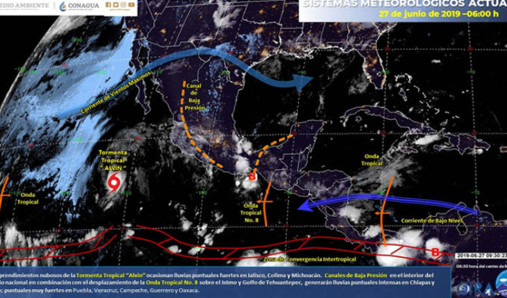
Mexico.- On this day, the tropical storm “Alvin” will be located southwest of the coasts of Baja California Sur, far from the country, however, the cloudy landslides associated with its circulation will keep heavy spot rains in Jalisco, Colima and Michoacán. A low pressure channel over the interior of the territory, will interact with tropical wave No. 8, south of the coasts of Oaxaca and with a new tropical wave that will approach at night south of the Yucatan Peninsula, generating intense spot rains in Chiapas and T as well as heavy rains to very heavy rains in southern, central and eastern Mexico, these rains will be accompanied by electric shocks, possible hail falls and wind gusts.
Precipitation forecast for today 27 June 2019:
Very heavy rains at intense points (75 to 150 liters per square meter): Chiapas and Tabasco.
Heavy rains at very strong points (50 to 75 liters per square meter): Puebla, Veracruz, Guerrero, Oaxaca and Campeche.
Intervals of showers with heavy occasional rains (25 to 50 liters per square meter): San Luis Potosí, Jalisco, Colima, Michoacán, Querétaro, State of Mexico and Yucatan.
Intervals of showers (5.1 to 25 liters per square meter): Nuevo León, Tamaulipas, Nayarit, Guanajuato, Hidalgo, Mexico City, Morelos, Tlaxcala and Quintana Roo.
Isolated rains (0.1 to 5.0 liters per square meter): Chihuahua, Coahuila, Durango, Zacatecas and Aguascalientes.
On surveillance, Tropical Storm “Alvin” southwest of the coasts of Baja California Sur; reinforces the inflow of moisture and rain into the west of the national territory. For more information, see the tropical cyclone warning in the Pacific Ocean via:
https://smn.conagua.gob.mx/es/pronosticos/avisos/aviso-de-ciclon-tropical-en-el-oceano-pacifico
Storm zones are accompanied by electric shocks, rippling wind and possible hail fall, as well as possible landslide on mountainous slopes.
Maximum temperature forecast for today 27 June 2019:
Temperatures above 45oC: Areas of Sonora, Sinaloa and Chihuahua.
Temperatures from 40 to 45oC: Areas of the Baja California Peninsula, Coahuila, Nuevo León, Tamaulipas, Michoacán, Guerrero, Veracruz, Campeche and Yucatan.
Temperatures from 35 to 40oC: Areas of San Luis Potosí, Nayarit, Jalisco, Colima, Chiapas, Oaxaca, Tabasco and Quintana Roo.
Wind Forecast for Today 27 June 2019:
Wind with gusts greater than 50 km/h: Baja California Peninsula, Sonora, Durango, Chihuahua, Coahuila, Zacatecas, Nuevo León, San Luis Potosí, Oaxaca, Chiapas, Campeche, Yucatan and Quintana Roo.
Forecast by region:
Mexico Valley: Cloudy sky during the day with banks of morning fog. Heavy spot rains in the State of Mexico and intervals of showers in Mexico City, accompanied by electric shocks. Wind from the north of 10 to 25 km/h with gusts that can exceed 40 km/h. In Mexico City, a maximum temperature of 26 to 28oC and a minimum of 14 to 16oC is expected. For the State of Mexico, maximum temperature from 23 to 25oC and minimum from 8 to 10oC.
Baja California Peninsula: Clear sky most of the day with banks of morning fog on the western coast of Baja California. Warm atmosphere, north component wind of 10 to 25 km/h with gusts greater than 40 km/h.
North Pacific: Clear sky in the morning and half cloudy in the afternoon. Very hot atmosphere and west component wind of 10 to 25 km/h with gusts greater than 40 km/h in Sonora and Sinaloa.
Pacific Center: Cloudy sky with heavy spot rains in Jalisco, Colima and Michoacán and intervals of showers in Nayarit. Such rains shall be accompanied by electric shocks, as well as a swell of 2 metres on the coasts of those states. Very warm atmosphere and easterly and southeast wind from 20 to 35 km/h.
South Pacific: Cloudy sky with intense spot rains at night and early Friday in Chiapas, as well as very heavy rains in Oaxaca and Guerrero, which will be accompanied by electric shocks and possible hailstorms. Warm atmosphere and variable direction wind from 15 to 30 km/h with gusts of 50 km/h.
Gulf of Mexico: Cloudy sky throughout the day with intense spot rains in Tabasco, very strong in Veracruz and intervals of showers in Tamaulipas, all accompanied by electric shocks and possible hailstones. Warm atmosphere and south and southeast wind from 10 to 25 km/h with gusts greater than 50 km/h.
Yucatan Peninsula: Cloudy skies in the afternoon with very strong occasional rains at night and early Friday in Campeche, as well as strong in Yucatan and shower intervals in Quintana Roo. Wind from the southeast of 10 to 25 km/h and gusts greater than 50 km/h, as well as very warm atmosphere.
Mesa del Norte: Cloudy sky in the afternoon with heavy occasional rains in San Luis Potosí and intervals of showers in Nuevo León, accompanied by electric shocks and possible hail. Warm atmosphere and east component steering wind of 15 to 30 km/h with gusts greater than 50 km/h.
Central Table: Cloudy sky throughout the day with very heavy rains in Puebla; strong in Querétaro and intervals of showers in Guanajuato, Hidalgo, Morelos and Tlaxcala; all accompanied by electric shocks. Warm environment and variable direction wind from 10 to 25 km/h with gusts of 40 km/h in storm zones and possible hail fall.
The maximum rainfall of the last 24 hours (in millimeters) was recorded in:
Matlapa, S.L.P., 139.0; The Fig, See., 65.0; Finca Chayabé, Chis., 57.9; New Laredo, Tamps., 44.3; Monclova, Camp., 34.0; Forest Shed (Tlalpan), CDMX, 25.6; La Palma, Mich., 23.0; Zula River, Jal., 22.4; Teziutlán, Pue., 18.0; La Laguna, Hgo., 16.9 and Chiconautla I (Ecatepec), Edo. Mexico, 12.4.
The maximum temperatures (in C) were recorded in:
Choix, Sin., 43.1; Cd. Juárez, Chih., 42.5; Hermosillo, Son., 42.0; Valladolid, Yuc., 41.0; Cottons, B.C., 39.1; La Paz, B.C.S., 38.5; Campeche, Camp., 38.3 and Tacubaya, CDMX, 27.2.
The minimum temperatures (in C) were recorded in:
Amecameca, Edo. Mexico, 3.4; El Chico (Pachuca), Hgo., 3.9; The Vergel, Chih., 6.3; Perote, Ver., 6.9 and Tacubaya, CDMX, 15.0.
Source: National Weather Service
Mtf
translated from Spanish: Heavy rains in western and southeastern Mexico
June 27, 2019 |


