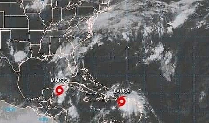
Two tropical storms roam the Caribbean on Saturday with potentially historic threats to the U.S. coast in the Gulf of Mexico. One storm generated rain in Puerto Rico and the Virgin Islands as the other moves between the Yucatan Peninsula in southern Mexico, and Cuba.Se expects tropical storms Laura and Marco to approach the U.S. coast with the force of a hurricane or near-hurricane. The current and uncertain route of both meteors could take them to the states of Texas or Louisiana.There have never been two hurricanes simultaneously in the Gulf of Mexico, according to data available since at least 1900, said Phil Klotzbach, hurricane researcher at Colorado State University. The last time there were two tropical storms together in the Gulf of Mexico was in 1959, he claimed. The last time two storms hit the U.S. mainland 24 hours or less was in 1933, Klotzbach.The U.S. National Hurricane Center (NHC) expects both meteors to gather Tuesday in the Gulf of Mexico, with Marco’s eye hitting Texas and Laura’s vortex touching land less than a day later, though the two routes remain uncertain.” These are unprecedented times,” Mississippi Gov. Tate Reeves said at a news conference Saturday at which he declared a state of emergency. “We are facing not only two potential storms in the next couple of hours, but we are also dealing with COVID-19.” Reeves urged the population to prepare for the arrival of storms and, if possible, look for places to take refuge other than public shelters. In the early hours of Saturday, Laura was already causing rain in Puerto Rico and the Virgin Islands and was expected to pack the Dominican Republic, Haiti and areas of Cuba on the day west. Puerto Rico Governor Wanda Vazquez declared a state of emergency and warned that the floods could be worse than tropical storm Isaiah three weeks ago, because the soil is saturated. He recommended that the population not leave the house. The storm toppled trees in the southern region of the island and more than 200,000 homes ran out of electricity throughout Puerto Rico.The storm vortex was about 95 kilometers (60 miles) southwest of Ponce, on the central south coast of Puerto Rica by Saturday afternoon, with sustained maximum winds of 85 km/h (50 mph), advancing westward at about 30 km/h (18 mph). For his part, Marcos continued to take hold and his center was located about 85 kilometers (50 miles) southwest of the western end of Cuba, with sustained maximum winds of 100 km/h (65 mph). It moved north-northwest at 19 km/h (12 mph) and is forecast to become a hurricane during the day. The NHC expects storms to remain sufficiently separate to prevent their direct interaction as the region prepares for the peak of the Atlantic hurricane season, which is forecast to be unusually active. Both storms were forecast to bring eight to 15 centimeters (three to six inches) of rain to the areas they will pass through or around, threatening widespread flooding in a vast region.” Many people are going to be hit by rain and storm surges in the Gulf of Mexico,” said Joel Cline, coordinator of the National Weather Service’s Tropical Program. “As you just don’t know, you really have to take precautions.” Meteorologists said that while atmospheric conditions are favorable for Laura to grow, her passage through Puerto Rico and the mountains of Haiti, the Dominican Republic and Cuba could weaken her before she enters the warm waters of the Gulf, which are conducive to her regaining strength.
translated from Spanish: Storms Laura and Marco create potentially historic threat to US
August 22, 2020 |


