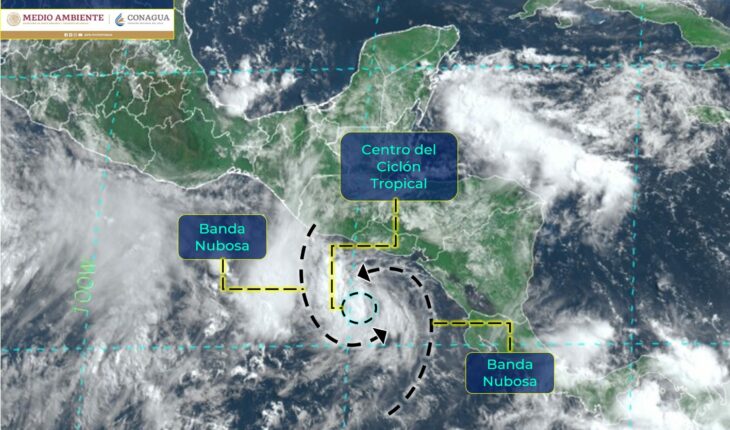
On Friday morning, Tropical Storm ‘Celia’ formed in the Pacific Ocean that, in interaction with a low pressure channel, will cause a rainstorm.
The National Water Commission (Conagua) warned of rains with intense rainfall (from 75 to 150 millimeters) in Chiapas, Tabasco, Quintana Roo; very strong (from 50 to 75 millimeters) in areas of Campeche, Oaxaca and Yucatan.
The rains indicated could generate increased levels of rivers and streams, landslides and floods in low-lying areas of the aforementioned states.
Read: Storm ‘Blas’ becomes a Category 1 hurricane; will cause rains in 4 states
Wind gusts of 50 to 60 km / h and waves of 1 to 3 meters high are also expected on the coast of Quintana Roo.
This morning the #TormentaTropical #Celia formed in the #Pacífico Ocean; in interaction with a #BajaPresión channel will cause from today a storm of #Lluvias. Learn more at ⬇️https://t.co/VVYNAjY7Uo pic.twitter.com/CMT8Azqs62
— CONAGUA Climate (@conagua_clima) June 17, 2022
Hurricane “Blas” of category 1, slowly moves away from the coasts of Colima and Jalisco, its extensive cloud bands generate moisture entry into the states of the Central Mexican Pacific.
Heavy to very heavy rains are expected from Nayarit to Guerrero; in addition to strong gusts of wind and high waves on the coasts of Baja California Sur, Sinaloa, Nayarit, Jalisco and Colima.
What we do at Animal Político requires professional journalists, teamwork, dialogue with readers and something very important: independence. You can help us keep going. Be part of the team.
Subscribe to Animal Político, receive benefits and support free journalism.#YoSoyAnimal


