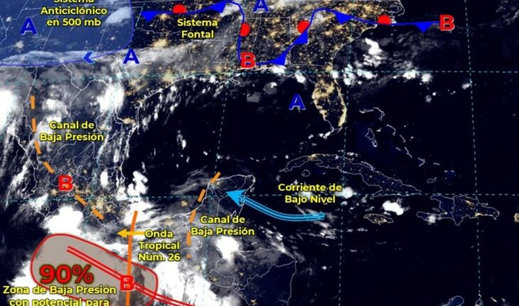
For today, tropical storm “Javier” will be located off the western coast of the Baja California Peninsula, its cloud bands will cause heavy punctual rains in Baja California and very strong punctual rains in Baja California Sur.Also, the Mexican monsoon over the northwest of the country, in combination with the entry of moisture generated by tropical storm “Javier” of the Pacific Ocean and with instability at high levels of the atmosphere will produce strong punctual rains in Sonora and Sinaloa, as well as very strong in Chihuahua and Durango.On the other hand, a low pressure channel extended along the Sierra Madre Occidental and the Central Mesa, coupled with instability at high levels of the atmosphere, will cause strong to very strong punctual rains in the west and center of the territory. In turn, an area of low pressure with potential cyclone (or possible tropical cyclone), which will be located south of Guerrero and will tend to absorb tropical wave No. 26 located south of Oaxaca, as well as the entry of moisture from the Caribbean Sea and Gulf of Mexico, will cause showers and heavy punctual rains in the Yucatan Peninsula, intense punctual rains over the northeast, south and southeast of the country, in addition to torrential punctual rains in Oaxaca, Veracruz and Puebla.The aforementioned rains will be accompanied by electric shocks, wind gusts and possible hail fall, in addition, they could cause an increase in the levels of rivers and streams, as well as landslides and floods in low-lying areas of the aforementioned states. Finally, the warm evening environment will prevail over most of the entities in the north and center of the country; hot in northwestern and northeastern Mexico, Pacific Ocean coast, north and west of the Yucatan Peninsula; and with very hot maximum temperatures, above 40°C in areas of Baja California and Sonora.Rain forecast for today September 3, 2022: Intense rains with torrential punctual (150 to 250 mm): Puebla, Oaxaca and Veracruz. Very heavy rains with intense punctual (75 to 150 mm): Coahuila, Nuevo León, San Luis Potosí, Michoacán, Guerrero, Chiapas Tamaulipas and Tabasco. Heavy rains with very strong punctual (50 to 75 mm): Baja California Sur, Chihuahua, Durango, Colima, Jalisco, Querétaro and Hidalgo. Intervals of showers with heavy punctual rains (25 to 50 mm): Baja California, Sonora, Sinaloa, Nayarit, State of Mexico, Mexico City, Morelos, Tlaxcala, Campeche and Quintana Roo. Rainfall intervals (5 to 25 mm): Zacatecas, Guanajuato and Yucatan. Isolated rains (0.1 to 5 mm): Aguascalientes. The aforementioned rains may be accompanied by strong electric shocks gusts of wind and possible hail fall, in addition to the fact that they could increase the levels of rivers and streams and cause landslides and floods in low areas Forecast of minimum temperatures for the morning of today, September 03, 2022: Minimum temperatures from 0 to 5 ° C: mountainous areas of the State of Mexico, Tlaxcala, Puebla and Veracruz. Forecast of maximum temperatures for today September 03, 2022: Maximum temperatures of 40 to 45 °C: Baja California and Sonora. Maximum temperatures of 35 to 40 °C: Nuevo León, Tamaulipas, Sinaloa, Nayarit, Jalisco, Colima, Michoacán, Hidalgo, Campeche and Yucatán. Maximum temperatures from 30 to 35 °C: Baja California Sur, Coahuila, Durango, Zacatecas, San Luis Potosí, Guanajuato, Querétaro, Morelos, Tlaxcala, Puebla, Veracruz, Tabasco and Quintana Roo. We recommend you read:Hexavalent health day from September in PueblaA AMLO went out of his way to give a supposed report at the time of the congressional session: NoroñaWind and wave forecast for today September 3, 2022: Wind with gusts of 60 to 80 km / h: coasts of Baja California, Baja California Sur and Oaxaca. Wind with gusts of 50 to 60 km / h: Sonora, Chihuahua, Coahuila, Durango, Zacatecas, San Luis Potosí, Aguascalientes, Jalisco and Guanajuato, as well as on the coasts of Guerrero, Chiapas, Tabasco, Campeche, Yucatán and Quintana Roo. Waves of 2 to 4 meters high: coasts of Baja California and Baja California Sur. Waves from 1 to 3 meters high: coast of Oaxaca.
Tropical Storm Javier will continue to affect
September 3, 2022 |


