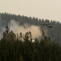
The European Union (EU) in Chile reported that the Copernicus Emergency Management Service has been activated, for the production of satellite maps in “rapid mapping” mode, in order to support the authorities with the emergency response to forest fires in the center-south of the country.
“Copernicus” is an EU programme aimed at developing information services based on Earth observation by satellite and in situ (non-space) data. The system is implemented by the European Commission (EC), with support from the European Space Agency (ESA) for the space component and the European Environment Agency (EEA) for the in situ component.
“The aim of Copernicus is to monitor and forecast the state of the environment on land, sea and atmosphere, to support climate change mitigation and adaptation strategies, efficient management of emergency situations and improvement of the security of all citizens,” its website details.
Josep Borrell, the high representative of the Union for Foreign Affairs and Security Policy and vice president of the European Commission in the community executive of Ursula von der Leyen, said on Twitter that he spoke with Chancellor Antonia Urrejola, to convey his solidarity in the face of the devastating fires ravaging Chile. “The EU is helping and has activated #EUCivilProtectionMechanism. All our support to the people of Chile,” he said.
For her part, the head of the Ministry of Foreign Affairs, Minister Antonia Urrejola, thanked the solidarity of the EU, “for accompanying us in these difficult times.”
“Thank you to the EU for the collaboration. As President Gabriel Boric says, solidarity transcends borders,” added the Chilean foreign minister.
It is worth mentioning that, in addition, thirteen countries of the European Union (EU) offered search and rescue teams on Monday, in the face of the catastrophe registered in the regions of Ñuble, Biobío and La Araucanía, according to the European Commission.
It 🇪🇺 has been activated by the @CopernicusEU Emergency Management Service for the production of satellite maps in rapid mapping mode, in order to support authorities with the emergency response to forest fires in 🇨🇱 .
Check them 👉out https://t.co/q8NuyuwtF8 pic.twitter.com/DvkPu9h6bb
— EU in Chile 🇪🇺 (@UEenChile) February 6, 2023
Follow us on
"El reclamo puede ser genuino, pero construido sobre una mentira", apuntó el presidente Javier Milei…
El gobernador de la provincia de Buenos Aires, Axel Kicillof, encabezó un acto en Ensenada…
El diputado nacional de La Libertad Avanza, José Luis Espert, expresó su confianza en la…
Tras la masiva reaparición de Cristina Fernández de Kirchner, el presidente Javier Milei apuntó contra…
El principal propósito de la nueva comisión es evaluar los recursos humanos en el Senado,…
En una medida que busca redefinir las condiciones de los seguros de automóviles en Argentina,…
Esta web usa cookies.