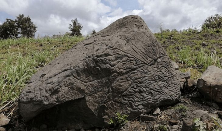
Colima.- The National Institute of Anthropology and History (INAH) recorded in the area of the Brotherhood of Suchitlán, Colima, a huge carved basaltic rock that functioned as a map in pre-Hispanic times. The petroglyph was registered on 7 June and its creation has been dated between 200 BC and 200 AD.
Researchers believe the stone was thrown by the Volcano of Fuego de Colima, 14 kilometers to the south and the pre-Hispanic inhabitants of Colima meticulously carved it into a ‘map’ of its territory; this is indicated by the designs and patterns it shows on its surface, and that it is not the only one of its kind in the state. “In the Archaeological Zone of La Campana, in the state capital alone, we have accounted for more than 100 petroglyphs,” said Julio Ignacio Martínez de la Rosa, owner of the local INAH.
INAH2
“The highest part of the stone – 1.70 meters high, an irregular width of between 2.12 and 2.77 m and thickness of between 60 centimeters and 1.70 m – holds an axis of approximately 20 degrees to the northeast, that is, it is oriented to the volcano of Fuego,” explained de la Rosa.
In turn, the archaeologist Rafael Platas Ruiz, appointed for the inspection of the cultural good, notes that it shows at least three engraving techniques (polishing, pecking and wear), which were used to represent the orographic and geographical landscape of the southern slope of the volcano, furrowed by canyons, runoffs and rivers that come down from the geological promontory.
The researcher at the INAH Colima Center said that on the main surface of the petroglyph, aligned with the colossus and also having a descent to the south, small circular holes were carved, representing the location of ancient communities. Also, on the east side, there are lines that allude to the orography of the region, abundant in hydrological truths and natural runoffs.


